Terra Sirenum Gullied Crater
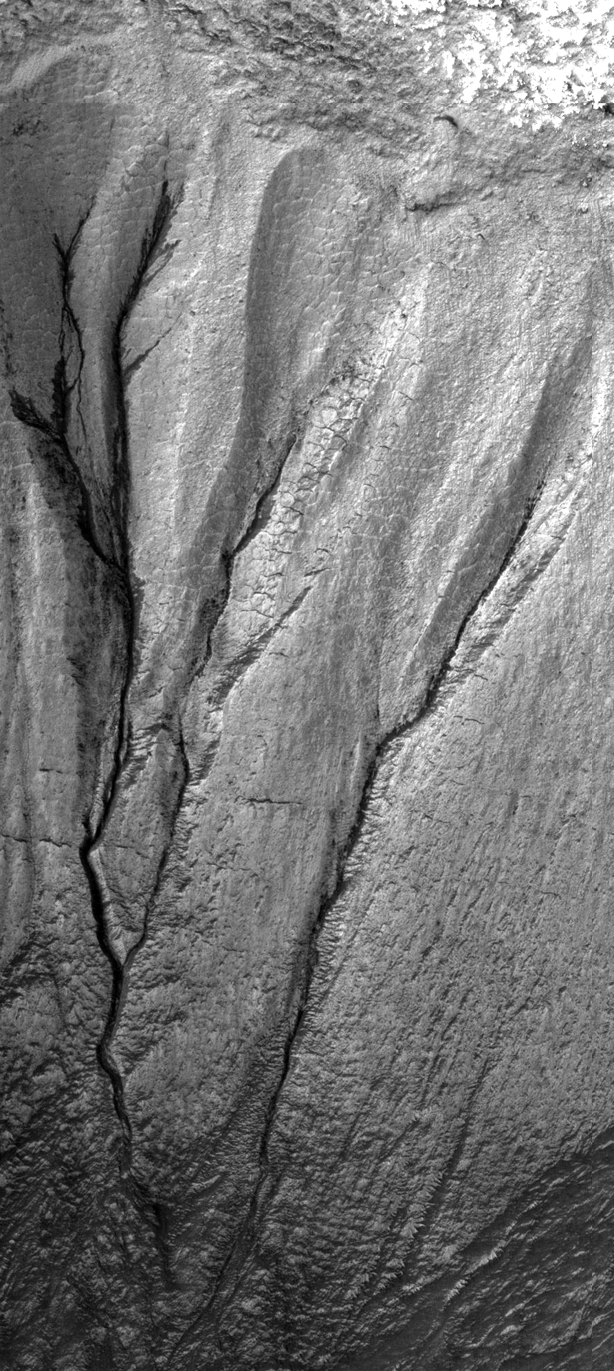 Highlighted Portion of HiRISE Image TRA_000878_1410
This is a full-resolution subset of image TRA_000878_1410, covering an area of approximately 220-by-500 m (730-by-1600 feet). It shows several gully systems carved in the walls of an unnamed crater 10 km (6 miles) in diameter, located in Terra Sirenum. Downhill is towards the bottom of the image, north is up. The gullies in this image are composed of multiple small tributaries, some as narrow as 1 pixel (50 cm or 20 inches). Polygonal features similar to polygons formed on terrestrial permafrosts (frozen soils) are ubiquitous on the south-facing walls of this crater, both around the gullies and on some gullies' walls. Whatever processes formed these gullies, they started long enough ago so there has been time for polygonal features to develop along their walls. Locally, some gullies' walls (west-facing walls in particular) look puzzlingly dark in this black-and-white image. Nearby areas, imaged in color by HiRISE, provided the evidence to solve this puzzle: the brighter walls are covered in whitish-bluish frost and therefore look brighter in the black-and-white image; frost-free materials (mostly on walls which, because of their orientation, may get some direct sunlight) look darker. Some of the gullies shown in this image, although well developed and locally deeply incised, seem to fade away before reaching the crater's floor. Current leading hypotheses explaining the origin of gullies include erosion from seepage or eruption of water from a subsurface aquifer, melting of ground ice, or surface snow; and dry landslides. The nature of gullies will be further investigated utilizing the high-resolution and color capabilities of HiRISE. (Note: Occasionally data is lost while being transmitted from Mars to Earth. When this happens it shows up as a series of black pixels).
Image TRA_000878_1410 was taken by the High Resolution Imaging Science Experiment (HiRISE) camera onboard the Mars Reconnaissance Orbiter spacecraft on October 3, 2006. The complete image is centered at -38.9 degrees latitude, 223.7 degrees East longitude. The range to the target site was 251.8 km (157.4 miles). At this distance the image scale is 50.4 cm/pixel (with 2 x 2 binning) so objects ~151 cm across are resolved. The image shown here [below] has been map-projected to 50 cm/pixel and north is up. The image was taken at a local Mars time of 3:38 PM and the scene is illuminated from the west with a solar incidence angle of 80 degrees, thus the sun was about 10 degrees above the horizon. At a solar longitude of 115.5 degrees, the season on Mars is Northern Summer.
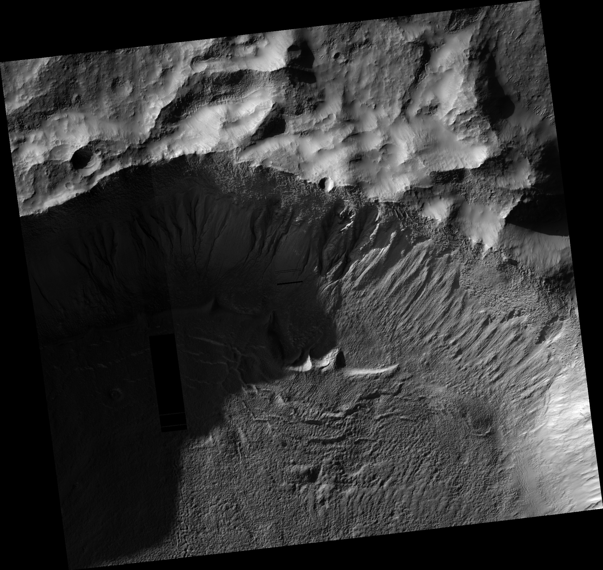 HiRISE Image TRA_000878_1410
Images from the High Resolution Imaging Science Experiment and additional information about the Mars Reconnaissance Orbiter are available online at:
http://hirise.lpl.arizona.edu/
or
For information about NASA and agency programs on the Web, visit: http://www.nasa.gov. NASA's Jet Propulsion Laboratory, a division of the California Institute of Technology in Pasadena, manages the Mars Reconnaissance Orbiter for NASA's Science Mission Directorate, Washington. Lockheed Martin Space Systems is the prime contractor for the project and built the spacecraft. The HiRISE camera was built by Ball Aerospace and Technology Corporation and is operated by the University of Arizona.