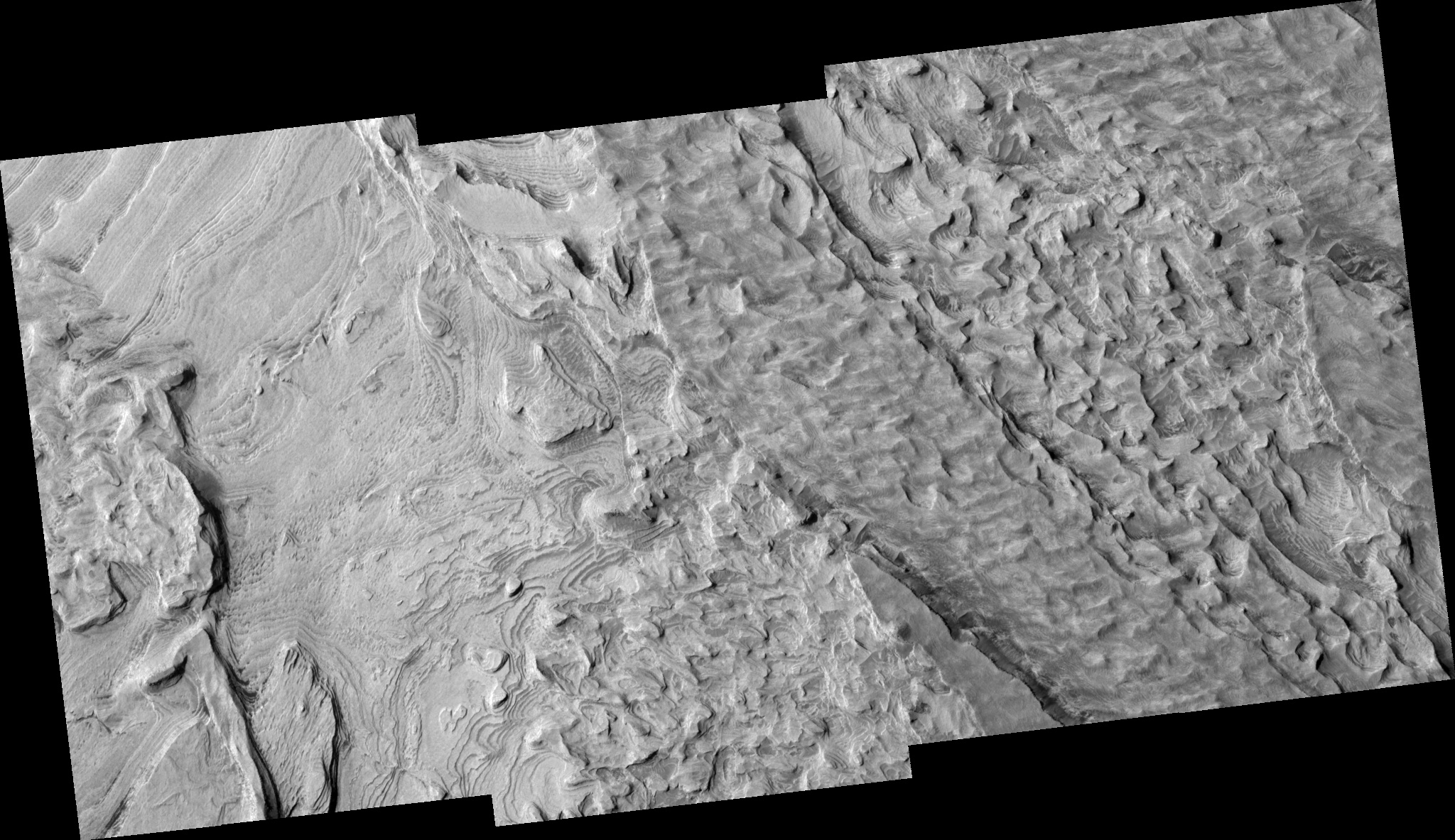
Layered Deposits in Becquerel Crater
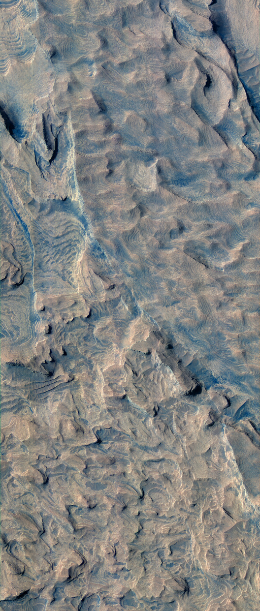
 This color image covers only the center swath of
the full image, and is composed of images acquired through infrared, red,
and blue-green filters. The color has been enhanced to better show the
subtle color differences. It is not natural color or how it would appear
to normal human vision.
This color image covers only the center swath of
the full image, and is composed of images acquired through infrared, red,
and blue-green filters. The color has been enhanced to better show the
subtle color differences. It is not natural color or how it would appear
to normal human vision.
This image is of a portion of a light-toned layered deposit on the floor of Becquerel crater. Several impact craters in Arabia Terra contain these light-toned layered deposits that could represent sedimentary rocks similar to those found at Meridiani Planum by the Opportunity rover. At HiRISE resolution, the number, thickness, lateral continuity,and texture of individual layers can be determined with unprecedented precision. To form a terrain such as this, sediments are first deposited in regular flat layers. Then erosion, most likely the wind, carves into the stack of layers, removing material to produce the stair-step pattern seen in the image. The key question scientists are trying to answer based on the characteristics of the layers is what the environment of deposition was. Were these sediments deposited in water, such as a lake, or were they deposited from the air, like dust or as volcanic ash-fall? The process of erosion is likewise uncertain, leaving behind both steep scarps and gentle slopes. The edges of layers at the top of some mesas and scarps are fracturing into large blocks. Such blocks may be seen down-slope in some cases, although surrounding surfaces are remarkably clear of large debris indicating they are friable and easily broken down into finer particles that appear as debris mantles around the base of these mesas. Materials with regular layers such as this are good places to look for and measure displacement along faults, which would indicate tectonic activity after emplacement. The roughly rectangular pattern of fine fractures on some layer surfaces is also seen for the first time here.
In the color image, rock surfaces devoid of debris appear brightest and yellowish to light red in color. The layers themselves appear remarkably uniform in color, suggesting limited compositional variation. In hollows and next to breaks in slope, darker red to slightly bluish colored material occasionally collects. These materials are tinged bluer on slopes facing away from the sun, suggesting the incidence angle of sunlight on the material influences its color. The formation of dunes by this material indicates it is moved around by the wind, which probably also keeps the exposed rock surfaces clear. The most intense blue color, without a reddish tinge, is often associated with boulders fallen from mesas, indicating these blue areas are likely rich in rock fragments. This correlation of color and rocks helps highlight areas of debris fallen from mesas and cliffs, which were difficult to identify in the black & white image, and even identifies other areas of rock-rich debris without visible boulders. Such rocky areas are seen in color to be concentrated on slopes below eroding layers and ridges, in low areas, and within the cracks of the fractured terrain.
Image TRA_000873_2015 was taken by the High Resolution Imaging Science Experiment (HiRISE) camera onboard the Mars Reconnaissance Orbiter spacecraft on Sunday, 04 October 2006. The complete image is centered at 21.4 degrees latitude, 351.9 degrees East longitude. The range to the target site was 284.0 km (177.5 miles). At this distance the image scale ranges from 28.4 cm/pixel (with 1 x 1 binning) to 113.6 cm/pixel (with 4 x 4 binning). The image shown here [below] has been map-projected to 25 cm/pixel and north is up. The image was taken at a local Mars time of 3:24 PM and the scene is illuminated from the west with a solar incidence angle of 47 degrees, thus the sun was about 43 degrees above the horizon. At a solar longitude of 115.3 degrees, the season on Mars is Northern Summer.
 HiRISE Product ID: TRA_000873_2015
Images from the High Resolution Imaging Science Experiment and additional information about the Mars Reconnaissance Orbiter are available online at:
http://www.nasa.gov/mro
or
http://HiRISE.lpl.arizona.edu.
For information about NASA and agency programs on the Web, visit: http://www.nasa.gov. NASA's Jet Propulsion Laboratory, a division of the California Institute of Technology in Pasadena, manages the Mars Reconnaissance Orbiter for NASA's Science Mission Directorate, Washington. Lockheed Martin Space Systems is the prime contractor for the project and built the spacecraft. The HiRISE camera was built by Ball Aerospace and Technology Corporation and is operated by the University of Arizona.