Medusae Fossae
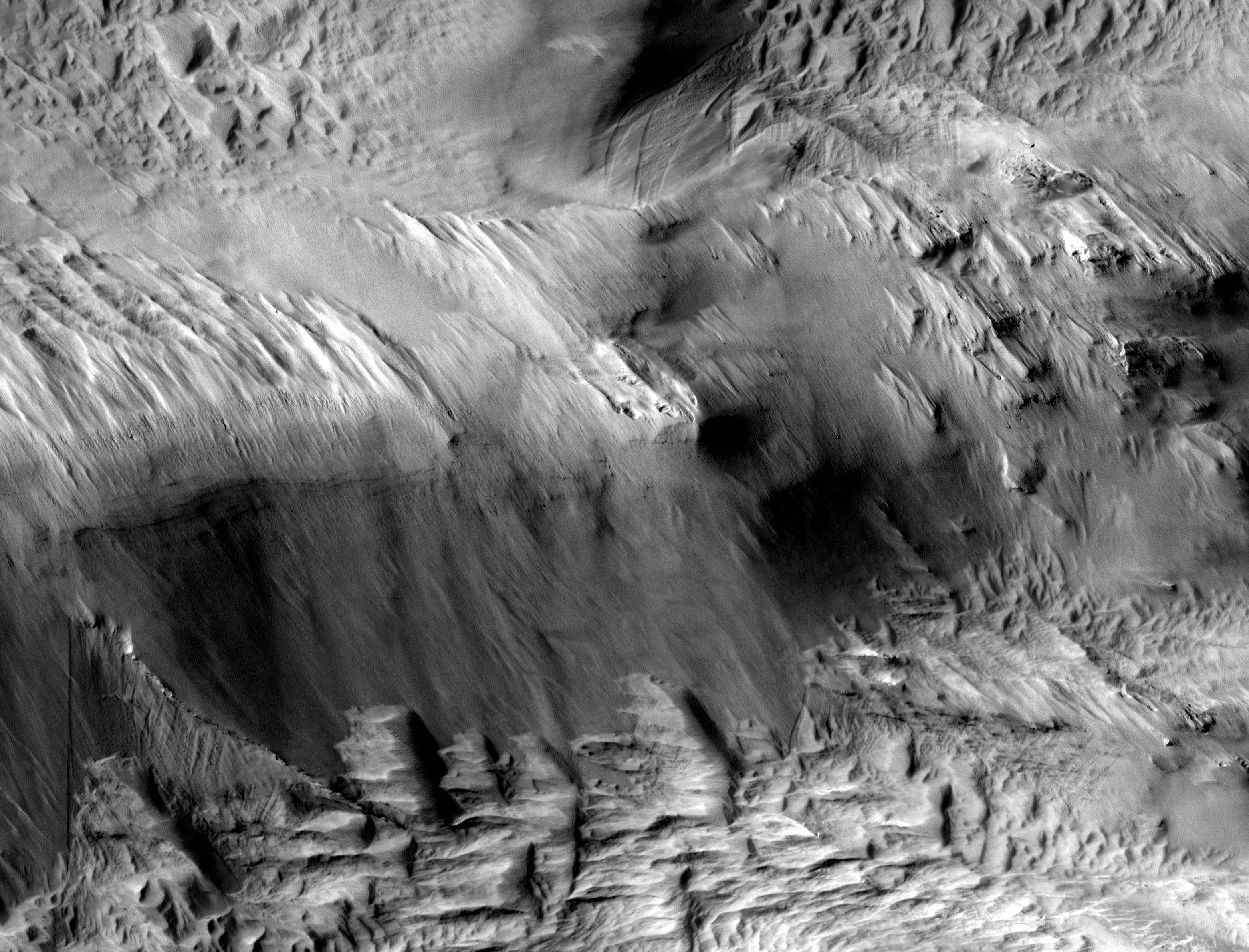 Highlighted Portion of HiRISE Image TRA_000865_1905
This image covers a portion of an outcrop of the Medusae Fossae Formation, a series of light-toned terrains in the Martian mid-latitudes. This exposure is southwest of Olympus Mons, the largest volcano in the Solar System. The Medusae Fossae has been and remains one of the most enigmatic features on Mars. The unit is characterized by wind-sculpted landforms, most notably eroded ridges known as yardangs. The composition of the Medusa Fossae is not known, but candidates include indurated (hardened) volcanic ash or remnants of dust-ice mixtures that formed in a different Martian climate. This HiRISE image reveals new details of the Medusae Fossae. Compare this image to the earlier release of TRA_000828_1805, another part of the Medusae Fossae thousands of kilometers away. Evidence of wind etching is seen throughout this image. Based on yardangs on Earth, the wind direction which dissected this region can be estimated from the direction of blunt to tapered ends of positive relief landforms. Separate sets of yardangs are located at the top and base of the cliff running across the middle of the sub-image. The upper and lower yardangs have shapes indicative of southeasterly and easterly, respectively, wind directions. One hypothesis is that the material composing both sets of yardangs eroded at the same time, in which case the two directions are attributable to topographic effects on wind flow. Another possibility is that the yardangs were eroded at different time periods characterized by distinct regional wind directions. Nearby loose material has also been moved by landslides, as indicated by the shallow troughs that are oriented downhill. On the slope separating the two yardang sets are several distinct layers, some containing rocks. These are similar to the yardangs seen in image TRA_00828_1805, which also showed rocky bedding. Most of these layers are approximately horizontal, and could be wind deposited sediments that have been indurated in the distant past. However, in the lower left-hand corner of the sub-image, there is a thin resistant layer that crosses diagonally across the other layers. On Earth, such features are often caused by either thin intrusions of magma (called "dikes" by geologists) or faults that have been indurated by fluids.
Image TRA_000865_1905 was taken by the High Resolution Imaging Science Experiment (HiRISE) camera onboard the Mars Reconnaissance Orbiter spacecraft on October 2, 2006. The complete image is centered at 10.2 degrees latitude, 211.5 degrees East longitude. The range to the target site was 276.3 km (172.7 miles). At this distance the image scale ranges from 27.6 cm/pixel (with 1 x 1 binning) to 55.3 cm/pixel (with 2 x 2 binning). The image shown here [below] has been map-projected to 25 cm/pixel and north is up. The image was taken at a local Mars time of 3:26 PM and the scene is illuminated from the west with a solar incidence angle of 51 degrees, thus the sun was about 39 degrees above the horizon. At a solar longitude of 115.1 degrees, the season on Mars is Northern Summer.
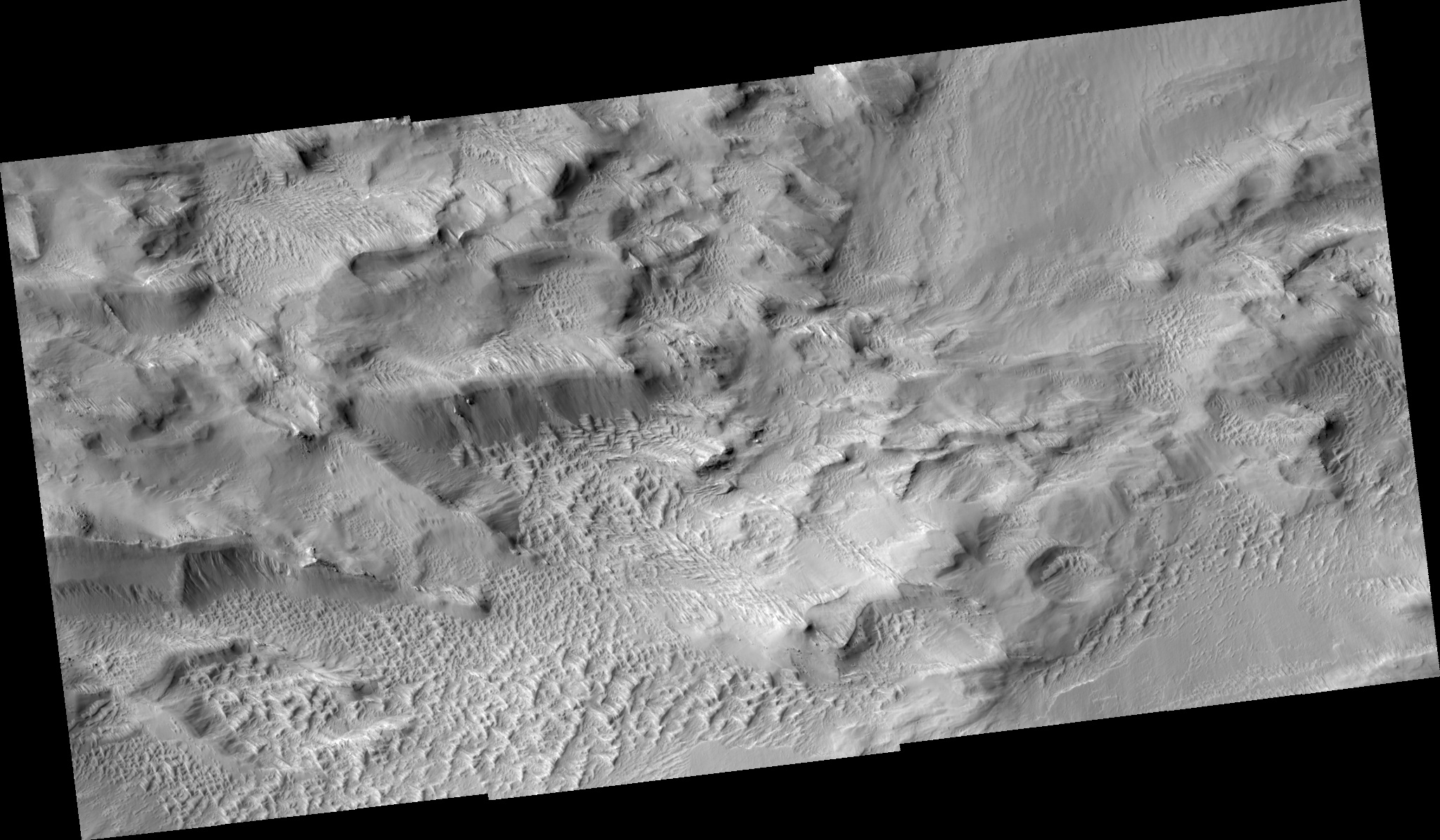 HiRISE Image TRA_000865_1905
Images from the High Resolution Imaging Science Experiment and additional information about the Mars Reconnaissance Orbiter are available online at:
http://hirise.lpl.arizona.edu/
or
For information about NASA and agency programs on the Web, visit: http://www.nasa.gov. NASA's Jet Propulsion Laboratory, a division of the California Institute of Technology in Pasadena, manages the Mars Reconnaissance Orbiter for NASA's Science Mission Directorate, Washington. Lockheed Martin Space Systems is the prime contractor for the project and built the spacecraft. The HiRISE camera was built by Ball Aerospace and Technology Corporation and is operated by the University of Arizona.