Mawrth Vallis Mesa
 Highlighted Portion of HiRISE Image TRA_000847_2055
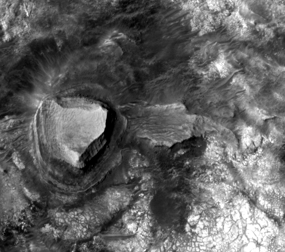
This is a full-resolution subset of image TRA_000847_2055, acquired over the Mawrth Vallis region; it covers an area of approximately 230-by-200 m (750-by-650 feet). The landscape in this region is dominated by dark-colored mesas like the one in this image. The mesas are formed by materials of diverse hardness and competence (rigidity), as shown by alternating close-to vertical and gentler slopes. Layers less than 3 pixels thick (that is, less than 75 cm or 30 inches) can be identified in this image. Layers also differ in color, as shown by the alternating darker and brighter gray tones. Single blocks the size of a beach ball (50 cm or 20 inches) can be singled-out in the slopes of the mesa. Dark fine-grained materials, movable by wind, form linear dunes such as the ones on the NE section of this image; some of them are almost 30 m (99 feet) long. Terrestrial linear dunes are indicative of wind regimes roughly parallel to the dunes' long axis. Other prominent features in this image are the light-colored materials toward the south and east, which appear to be densely fractured; their nature will be further investigated utilizing the high-resolution and color capabilities of HiRISE. The Mawrth Vallis region holds special interest because of the presence of phyllosilicate minerals, according to Mars Express OMEGA spectral data. These phyllosilicates, which in nearby areas are most consistent with iron-rich clays, form only if water is available. On Earth they occur in (among other environments) weathered volcanic rocks and hydrothermal systems, where volcanic activity and water interact.
Image TRA_000847_2055 was taken by the High Resolution Imaging Science Experiment (HiRISE) camera onboard the Mars Reconnaissance Orbiter spacecraft on October 1, 2006. The complete image is centered at 25.3 degrees latitude, 340.7 degrees East longitude. The range to the target site was 287.0 km (179.3 miles). At this distance the image scale ranges from 28.7 cm/pixel (with 1 x 1 binning) to 114.8 cm/pixel (with 4 x 4 binning). The image shown here [below] has been map-projected to 25 cm/pixel and north is up. The image was taken at a local Mars time of 3:23 PM and the scene is illuminated from the west with a solar incidence angle of 46 degrees, thus the sun was about 44 degrees above the horizon. At a solar longitude of 114.4 degrees, the season on Mars is Northern Summer.
 HiRISE Image TRA_000847_2055
Images from the High Resolution Imaging Science Experiment and additional information about the Mars Reconnaissance Orbiter are available online at:
http://hirise.lpl.arizona.edu/
or
For information about NASA and agency programs on the Web, visit: http://www.nasa.gov. NASA's Jet Propulsion Laboratory, a division of the California Institute of Technology in Pasadena, manages the Mars Reconnaissance Orbiter for NASA's Science Mission Directorate, Washington. Lockheed Martin Space Systems is the prime contractor for the project and built the spacecraft. The HiRISE camera was built by Ball Aerospace and Technology Corporation and is operated by the University of Arizona.