Yardangs in the Medusae Fossae Formation
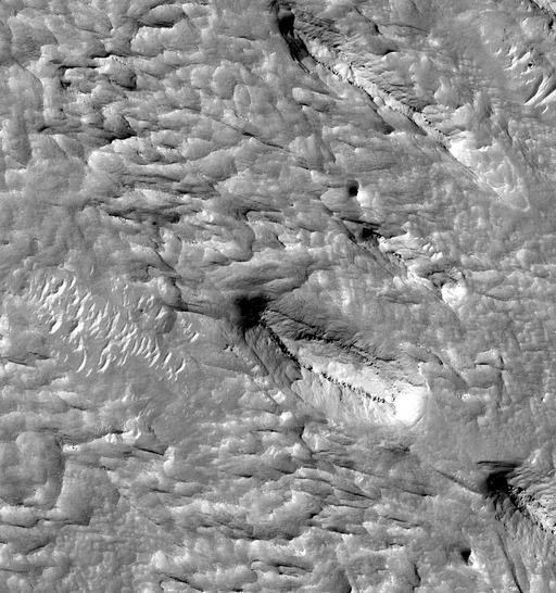
 Highlighted Portion of HiRISE Image TRA_000828_1805
This image covers a portion of an outcrop of the Medusae Fossae Formation, a series of light-toned terrains in the Martian mid-latitudes. The Medusae Fossae has been and remains one of the most enigmatic features on Mars. The unit is characterized by wind-sculpted landforms, most notably eroded ridges known as yardangs. The composition of the Medusae Fossae is not known, but candidates include indurated (hardened) volcanic ash or remnants of dust-ice mixtures that formed in a different Martian climate. This HiRISE image reveals new details of the Medusae Fossae. Three prominent yardangs are seen, at upper right, lower center right, and partially at lower right. They are aligned with their long axes pointing NW-SE, with tapered ends on the NW, consistent with erosion from a southeasterly wind. One or more hard rocky layers within the yardangs are visible, with the layers commonly segregated into discreet boulders. Isolated rocks are seen on the slopes and at the base of the yardangs, indicating that some formed from breakup of the layers. The rocks may be similar in composition to the softer, non-rocky parts of the yardangs, but simply more indurated. Alternatively, they may be compositionally distinct, challenging current hypotheses for the origin of the Medusae Fossae. Light-toned ridges at center left have a gross morphology similar to that of barchanoid dunes, formed from wind-blown sand. If these are dunes or ripples, their orientation is consistent with the presumed wind direction that carved the yardangs. However, zooming in to full resolution reveals flat tops, grooves, and smaller, darker ripple forms to the northwest of the ridges. Therefore if these are dunes, they seem indurated.
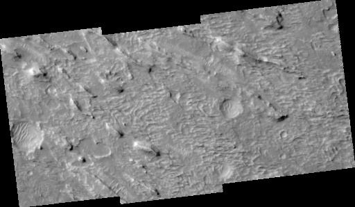
Image TRA_000828_1805 was taken by the High Resolution Imaging Science Experiment (HiRISE) camera onboard the Mars Reconnaissance Orbiter spacecraft on September 30, 2006. The complete image is centered at 0.5 degrees latitude, 142.1 degrees East longitude. The range to the target site was 270.1 km (168.8 miles). At this distance the image scale ranges from 27.0 cm/pixel (with 1 x 1 binning) to 108.1 cm/pixel (with 4 x 4 binning). The image shown here [below] has been map-projected to 25 cm/pixel and north is up. The image was taken at a local Mars time of 3:27 PM and the scene is illuminated from the west with a solar incidence angle of 55 degrees, thus the sun was about 35 degrees above the horizon. At a solar longitude of 113.7 degrees, the season on Mars is Northern Summer.
 HiRISE Image TRA_000828_1805
Images from the High Resolution Imaging Science Experiment and additional information about the Mars Reconnaissance Orbiter are available online at:
http://hirise.lpl.arizona.edu/
or
For information about NASA and agency programs on the Web, visit: http://www.nasa.gov. NASA's Jet Propulsion Laboratory, a division of the California Institute of Technology in Pasadena, manages the Mars Reconnaissance Orbiter for NASA's Science Mission Directorate, Washington. Lockheed Martin Space Systems is the prime contractor for the project and built the spacecraft. The HiRISE camera was built by Ball Aerospace and Technology Corporation and is operated by the University of Arizona.
