First HiRISE Image of Mars from Mapping Orbit: Ius Chasma, Valles Marineris: Fault In Ius Chasma
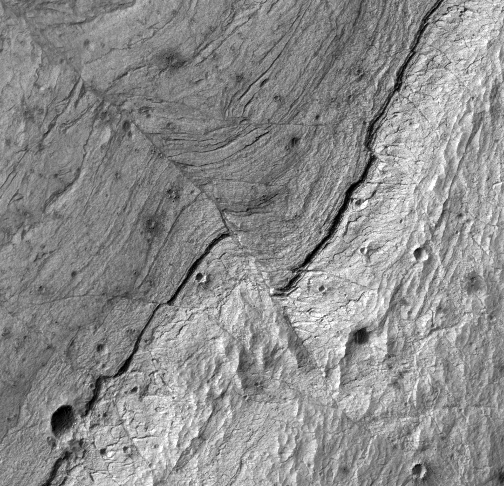 Highlighted Portion of HiRISE Image TRA_000823_1720
The sharpness and quality of HiRISE images allows geologists to work out the detailed geometry and sequence of events that have shaped the landscape. For example, this area shows exposures of light- and dark-toned layers of rock that have been faulted and folded. These rocks formed out of sedimentary deposits that originally accumulated in thick horizontal sequences, like a layer cake. These layers have since been tilted on-end and eroded, exposing the sequence of layers that we now see at the surface. A prominent dark layer extends through the center of the scene from the upper right to the lower left of the image. This dark layer is discontinuous and offset along a fault. The thin grey zone that extends from the upper left to the lower right of the image delineates the fault plane. This fault was originally a thrust, or compressional fault, that formed prior to the aforementioned tilting event. Tilting of this fault and the surrounding rock reveals a series of drag folds adjacent to the fault plane. These drag folds formed as the layered rock bent in response to friction along the fault plane as the thrust fault formed, prior to the tilting event. This fault offsets the dark layer by a maximum of 70-75 m. Smaller secondary folds and faults are also visible in this scene. The smallest resolved fault offset of an individual rock layer is 1-1.5 m. Also visible in this image are numerous small 4-10-m-diameter impact craters that are surrounded by ejecta of meter-scale boulders. This subscene is from the central portion of the full image [below].
Image TRA_000823_1720 was taken by the High Resolution Imaging Science Experiment (HiRISE) camera onboard the Mars Reconnaissance Orbiter spacecraft on September 29, 2006. The complete image is centered at -7.7 degrees latitude, 279.5 degrees East longitude. The range to the target site was 264.0 km (165.0 miles). At this distance the image scale ranges from 26.4 cm/pixel (with 1 x 1 binning) to 52.8 cm/pixel (with 2 x 2 binning). The image shown here [below] has been map-projected to 25 cm/pixel and north is up. The image was taken at a local Mars time of 3:29 PM and the scene is illuminated from the west with a solar incidence angle of 60 degrees, thus the sun was about 30 degrees above the horizon. At a solar longitude of 113.5 degrees, the season on Mars is Northern Summer.
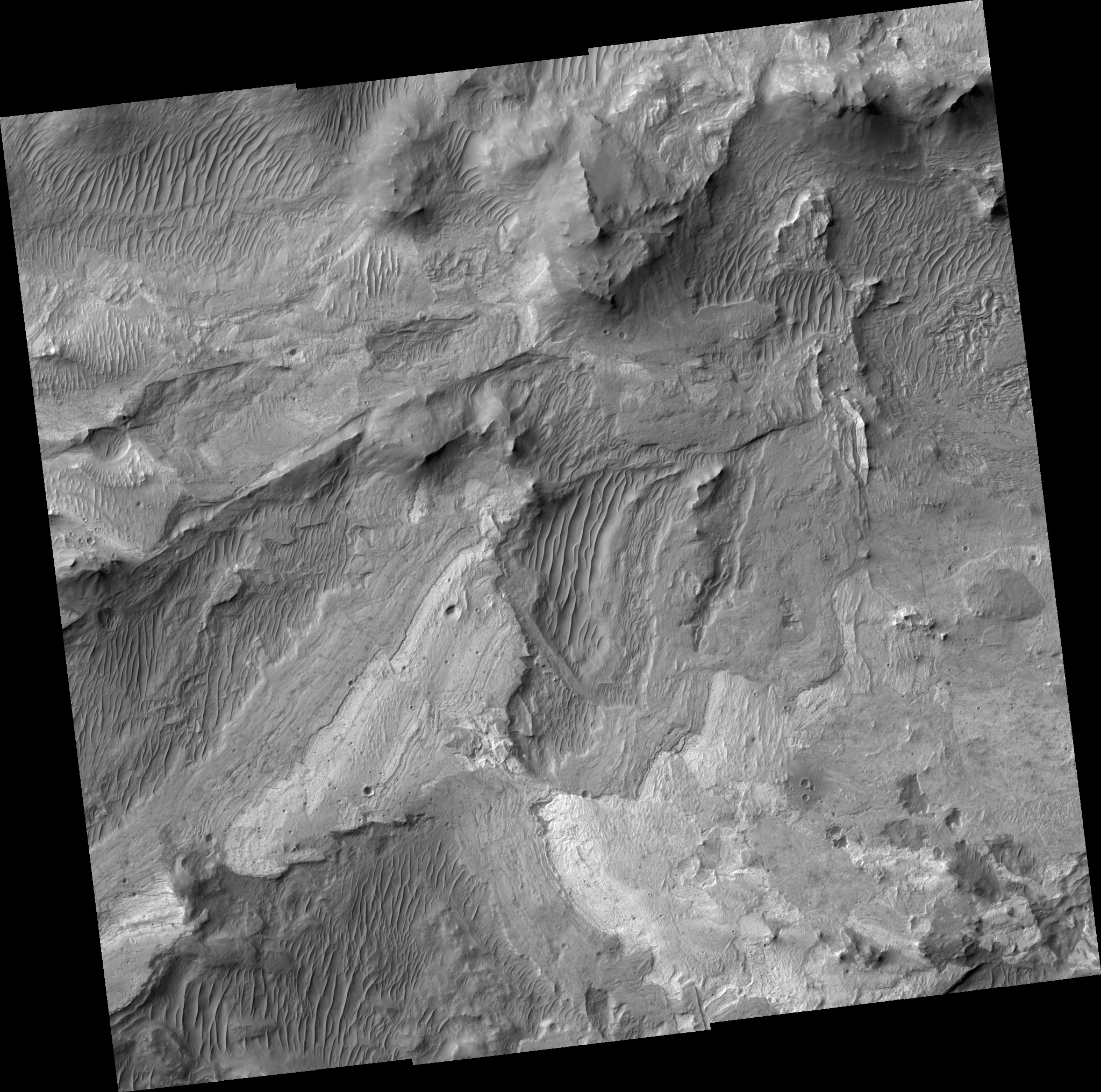 HiRISE Image TRA_000823_1720
Images from the High Resolution Imaging Science Experiment and additional information about the Mars Reconnaissance Orbiter are available online at:
http://hirise.lpl.arizona.edu/
or
For information about NASA and agency programs on the Web, visit: http://www.nasa.gov. NASA's Jet Propulsion Laboratory, a division of the California Institute of Technology in Pasadena, manages the Mars Reconnaissance Orbiter for NASA's Science Mission Directorate, Washington. Lockheed Martin Space Systems is the prime contractor for the project and built the spacecraft. The HiRISE camera was built by Ball Aerospace and Technology Corporation and is operated by the University of Arizona.