Mars Pathfinder Landing Site
 HiRISE Image PSP_001890_1995
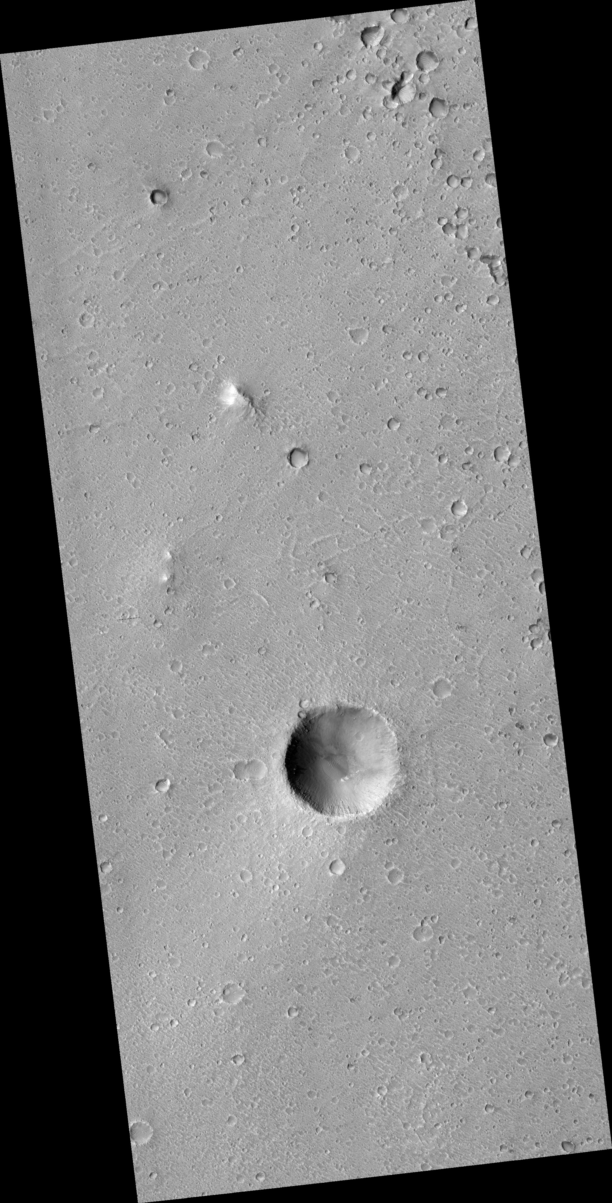
Caption writer: Nathan, with help from Tim Parker Reviewers: Alfred, Randy HiRISE has imaged the Mars Pathfinder landing site. Pathfinder landed on Mars on July 4, 1997 and continued operating until September 27 of that year. The landing site is on an ancient flood plain of the Ares and Tiu outflow channels. The image provides unprecedented detail of the geology of the region and hardware on the surface. This press release consists of six parts. 1. HiRISE Image (use full image PSP_001890_1995): This is the entire HiRISE image. The crater at center bottom is "Big Crater," the wall of which was visible from Pathfinder, located 3 km to the north. The two bright features to the upper left of Big Crater are the Twin Peaks, also observed by Pathfinder. The bright mound to the upper right of the Twin Peaks is North Knob, seen in Pathfinder images as peaking over the horizon. At this scale there is no obvious geologic evidence of an ancient flood. Rather, impact craters saturate the scene, attesting to an old surface. The age is probably on the order of 1.8-3.5 billion years, when the Ares and Tiu floods are estimated to have occurred. Wind-formed linear ripples and dunes are seen throughout and are concentrated within craters. Sets of polygonal ridges of enigmatic origin are seen east of the Pathfinder lander. Rocks are visible over the entire image, with heavy concentrations near fresh looking craters. Most of them are probably impact ejecta blocks. 2. Landing Site Region (closeup_labels.tif): This is a close-up of the area in the vicinity of the Pathfinder landing site. Major features are named. The white box outlines the area of the image, discussed next, where hardware is seen. 3. Hardware on the Surface (MPF_Parts.jpg): This image shows the Pathfinder lander on the surface. Zooming in, one can discern the ramps, science deck, and portions of the airbags on the Pathfinder lander (see next image, right side for greater detail). The backshell and parachute are to the south and four features that may be portions of the heat shield are identified. Two of these were visible from Pathfinder. At the time of that mission, the nearest object was provisionally identified as the back shell. However, analysis of the HiRISE image and reinterpretation of the Pathfinder images, plus an improved understanding of how hardware looks on the Martian surface based on the MER images and HiRISE images of those landing sites, indicates that the glint is bright enough that it may be the insulating material from the inside of the heat shield. The backshell and parachute were out of sight behind a ridge from Pathfinders's ground view. One of the three bright features, identified as heathshield debris, was also identified during the Pathfinder mission. 4. Topographic Map of landing site region (MPFtopo_HiRISE_annot.tif): These are maps of topography near the Pathfinder lander. They were constructed by assuming that the brightness of illuminated surfaces is proportional to slope. The white feature at center location 0,0 is the Pathfinder lander. The x and y axes scales are in meters. The close-up on the right compliments the Gallery Pan below. 5. Mars Pathfinder Gallery Panorama (manyrovers_full_annot_1lyr.tif): This version of the Gallery Pan, taken with the IMP camera during the Pathfinder mission, shows many of the "end of sol" locations for Sojourner, including the last know position (i.e., there was only one Sojourner rover). Annotations show the locations of rocks and other features that can be identified in the HiRISE overhead view. The proposed current location of the Sojourner Rover is indicated. Comparing the ground view with the HiRISE image, one can identify a feature at this location that is about the right size for Sojourner and that wasn't present when the Gallery Panorama was taken. 6. Topographic perspective of landing site region (MPF_HiRISE+pers1.jpg): This is a perspective view based on the topographic map and artificial color derived from Pathfinder and other data. The vertical scale is exaggerated by a factor of 3. The white feature at center is the Pathfinder lander.
Image PSP_001890_1995 was taken by the High Resolution Imaging Science Experiment (HiRISE) camera onboard the Mars Reconnaissance Orbiter spacecraft on December 21, 2006. The complete image is centered at 19.1 degrees latitude, 326.8 degrees East longitude. The range to the target site was 284.7 km (177.9 miles). At this distance the image scale is 28.5 cm/pixel (with 1 x 1 binning) so objects ~85 cm across are resolved. The image shown here has been map-projected to 25 cm/pixel and north is up. The image was taken at a local Mars time of 3:35 PM and the scene is illuminated from the west with a solar incidence angle of 52 degrees, thus the sun was about 38 degrees above the horizon. At a solar longitude of 154.0 degrees, the season on Mars is Northern Summer.
Images from the High Resolution Imaging Science Experiment and additional information about the Mars Reconnaissance Orbiter are available online at:
http://hirise.lpl.arizona.edu/
or
For information about NASA and agency programs on the Web, visit: http://www.nasa.gov. NASA's Jet Propulsion Laboratory, a division of the California Institute of Technology in Pasadena, manages the Mars Reconnaissance Orbiter for NASA's Science Mission Directorate, Washington. Lockheed Martin Space Systems is the prime contractor for the project and built the spacecraft. The HiRISE camera was built by Ball Aerospace and Technology Corporation and is operated by the University of Arizona.