Scarp within Chasma Boreale
 HiRISE Image PSP_001412_2650
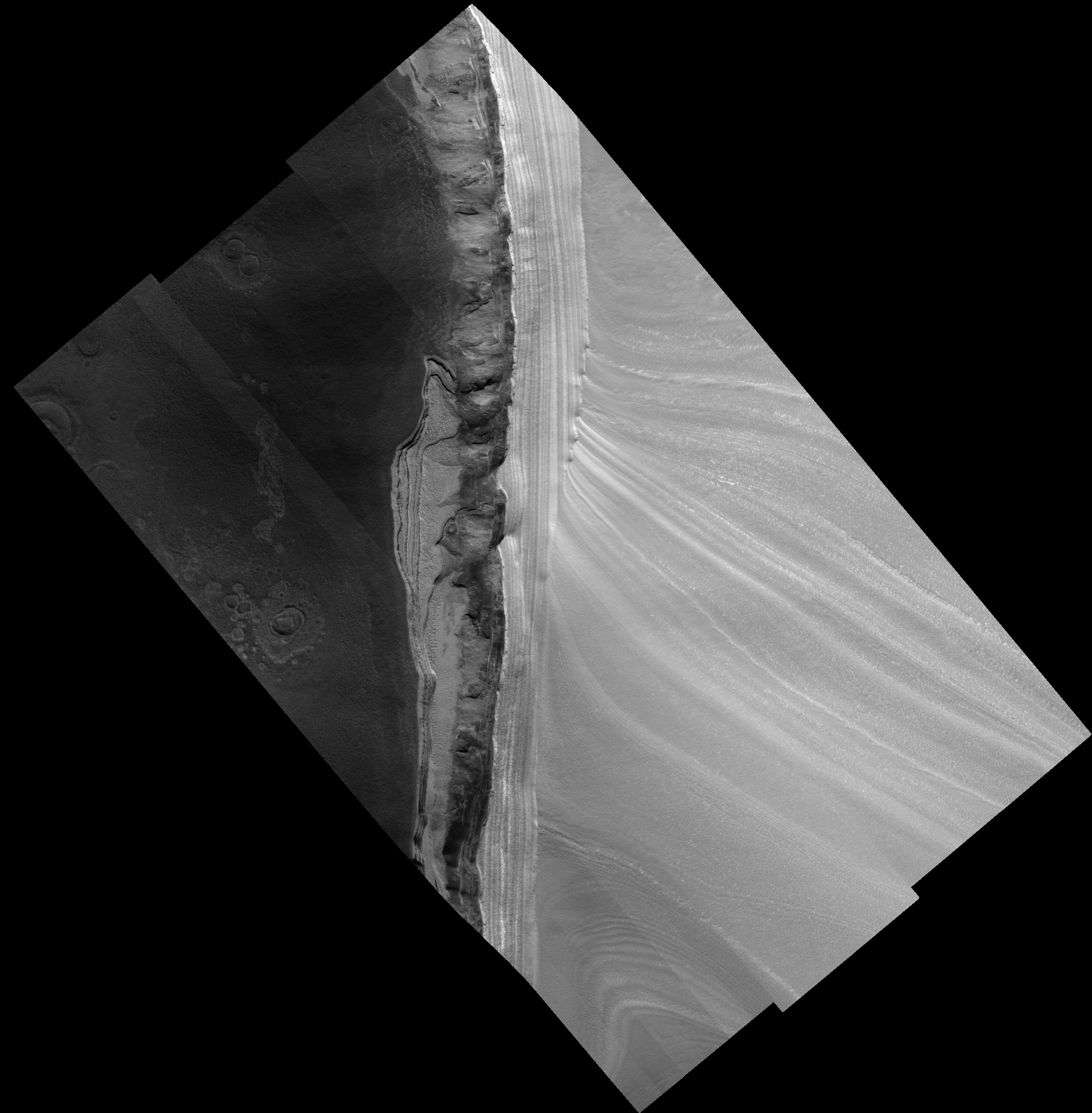
This image is of the north polar layered deposits (PLD) and underlying units exposed along the margins of Chasma Boreale. Chasma Boreale is the largest trough in the north PLD, thought to have formed due to outflow of water from underneath the polar cap, or due to winds blowing off the polar cap, or a combination of both. At the top and left of the image, the bright area with uniform striping is the gently sloping surface of the PLD. In the middle of the image this surface drops off in a steeper scarp, or cliff. At the top of this cliff we see the bright PLD in a side view, or cross-section. From these two perspectives of the PLD it is evident that the PLD are a stack of roughly horizontal layers. The gently sloping top surface cuts through the vertical sequence of layers at a low angle, apparently stretching the layers out horizontally and thus revealing details of the brightness and texture of individual layers. The surface of the PLD on the scarp is also criss-crossed by fine scale fractures. The layers of the PLD are probably composed of differing proportions of ice and dust, believed to be related to the climate conditions at the time they were deposited. In this way, sequences of polar layers are records of past climates on Mars, as ice cores from terrestrial ice sheets hold evidence of past climates on Earth. Further down the scarp in the center of the image the bright layers give way suddenly to a much darker section where a few layers are visible intermittently amongst aprons of dark material. The darkest material, with a smooth surface suggestive of loose grains, is thought to be sandy because similar exposures elsewhere show it to be formed into dunes by the wind. An intermediate-toned material also appears to form aprons draped over layers in the scarp, but its surface contains lobate structures that appear hardened into place and its edges are more abrupt in places, suggesting it may contain some ice or other cementing agent that makes it more competent, or resistent. At the base of the cliff, especially visible on the right side of the image, are several prominent bright layers with regular, rectangular-shaped polygons. Due to similarities in brightness and surface fracturing with the upper PLD, these bottom layers are also likely to be ice rich. The presence of sandy material sandwiched in between the upper PLD and these bottom layers suggests that the climate was once much different from the times during which the icier layers were deposited. The scattered bright and dark points are boulder-sized blocks that are likely pieces of the fractured PLD or other darker layers that have broken off and fallen downhill. At the bottom and right of the image, the floor of Chasma Boreale is dark, with a knobby texture and irregular polygons. Several circular features surrounded by an area that is slightly smoother, lighter, and raised relative to the chasm floor may be impact craters that have been modified after their formation in ice-rich ground.
Image PSP_001412_2650 was taken by the High Resolution Imaging Science Experiment (HiRISE) camera onboard the Mars Reconnaissance Orbiter spacecraft on November 14, 2006. The complete image is centered at 84.7 degrees latitude, 4.0 degrees East longitude. The range to the target site was 320.9 km (200.6 miles). At this distance the image scale ranges from 32.1 cm/pixel (with 1 x 1 binning) to 128.4 cm/pixel (with 4 x 4 binning). The image shown here has been map-projected to 25 cm/pixel. The image was taken at a local Mars time of 12:52 PM and the scene is illuminated from the west with a solar incidence angle of 67 degrees, thus the sun was about 23 degrees above the horizon. At a solar longitude of 135.3 degrees, the season on Mars is Northern Summer.
Images from the High Resolution Imaging Science Experiment and additional information about the Mars Reconnaissance Orbiter are available online at:
http://hirise.lpl.arizona.edu/
or
For information about NASA and agency programs on the Web, visit: http://www.nasa.gov. NASA's Jet Propulsion Laboratory, a division of the California Institute of Technology in Pasadena, manages the Mars Reconnaissance Orbiter for NASA's Science Mission Directorate, Washington. Lockheed Martin Space Systems is the prime contractor for the project and built the spacecraft. The HiRISE camera was built by Ball Aerospace and Technology Corporation and is operated by the University of Arizona.